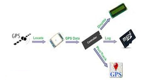
GPS INTERFACING WITH ARM
The Global Positioning System (GPS) is a space-based satellite navigation system that provides location and time information in all weather, anywhere on or near the Earth, where there is an unobstructed line of sight to four or more GPS satellites. It demonstrates the principle of interfacing GPS with ARM LPC2148.
Synopsis

The Global Positioning System (GPS) is a space-based satellite navigation system that provides location and time information in all weather, anywhere on or near the Earth, where there is an unobstructed line of sight to four or more GPS satellites. It demonstrates the principle of interfacing GPS with ARM LPC2148. The GPS module continuously transmits serial data (RS232 protocol) in the form of sentences according to NMEA standards. The latitude and longitude values of the location are contained in the GPGGA sentence (NMEA format).

Description

ARM is one of the major options available for embedded system developer. LPC2148 is the widely used IC from ARM-7 family. It is manufactured by Philips and it is pre-loaded with many inbuilt peripherals making it more efficient and a reliable option for the beginners as well as high end application developer.

ARM is a family of instruction set architectures for computer processors based on a reduced instruction set computing (RISC) architecture developed by British company ARM Holdings .A RISC-based computer design approach means ARM processors require significantly fewer transistors than typical processors in average computers. This approach reduces costs, heat and power use. These are desirable traits for light, portable, battery-powered devices including smartphones, laptops, tablet and notepad computers and other embedded systems. A simpler design facilitates more efficient multi-core CPUs and higher core counts at lower cost, providing higher processing power and improved energy efficiency for servers and supercomputers.


The ARM LPC2148 features are as follows:

1. Architecture: ARM v4T

2. Processor: ARM7-TDMI-S

3. Instructions: 32-bit ARM and 16-bit Thumb

4. Debug support: RT Embedded ICE, Embedded Trace interface

5. bStatic RAM: 32 KB

6. (On-chip)Additional: 8 KB for USB DMA

7. Flash Program: 512 KB

8. Mem.(On-chip)Programming: ISP/IAP via on-chip boot-loader program

9. GPIO No. of pins: up to 45 (fast GPIO lines, 5V tolerant), Configurable to fast GPIO

10. External Interrupts: Four; No. of pins: Nine

The ARM LPC2148 has two ports Port 0 and Port 1 respectively each port contains 32-bits for I/O operations. The Port 0 has 32-bit of I/O pins for individual directions and Port 1 has 32-bits of I/O pins for bidirectional purpose. It has two timers of each 32-bit. It has capable to storing 128-bit memory for interfacing.

Over the last few years, the ARM architecture has become the most pervasive 32-bitarchitecture in the world, with wide range of ICs available from various IC manufacturers. ARM processors are embedded in products ranging from cell/mobile phones to automotive braking systems. A worldwide community of ARM partners and third-party vendors has developed among semiconductor and product design companies, including hardware engineers, system designers, and software developers.

Global Positioning System (GPS) makes use of signals sent by satellites in space and ground stations on accurately determine their Earth to position on Earth. The interface is with a ARM LPC2148 microcontroller rated at 3.3V or a low rating which may not match exactly with the GPS modem. Therefore, there is a need to design additional power supply unit – other than the microcontroller power supply unit. Such a designing process includes rectification, filtration and regulation of units to obtain a regulated DC supply from the mains AC supply. The GPS itself does not need to transmit any information.

Radio Frequency signals sent from satellites and ground stations are received by the GPS. GPS makes use of these signals to determine its exact position. The signals received from the satellites and ground stations contain time stamps of the time when the signals were transmitted. By calculating the time difference between the time the signal was transmitted and the time the signal was received, and using the speed of the signal, the distance between the satellites and the GPS can be determined using a simple formula for distance using speed and time.


The GPS receiver module uses UART communication to communicate with controller or PC terminal. To communicate over UART or USART, we need three basic signals they are as follows:

• RXD (receive)

• TXD (transmit)

• GND (common ground).

So to interface UART with LPC2148, we just need the basic signals. Receive data from satellite to LPC2148 Development Board by using GPS module through UART0. The serial data is taken from the GPS module through MAX232 into the SBUF register of LPC2148 microcontroller (refer serial interfacing with LPC2148). The serial data from the GPS receiver is taken by using the Serial Interrupt of the controller. This data consists of a sequence of NMEA sentences from which GPGGA sentence is identified and processed.


A DB9 connector is used to connect this modem to the level shifter IC. While using GSM modem or PC interface to see the results (longitude and latitude), there arises a need to use multiplexer IC to interface with the microcontroller. Since the microcontroller has only one set of Rx and Tx pins, both GSM and GPS modem cannot be interfaced at a time.

The GPS concept is based on time and the known position of GPS specialized satellites. The satellites carry very stable atomic clocks that are synchronized with one another and with the ground clocks. Any drift from true time maintained on the ground is corrected daily. In the same manner, the satellite locations are known with great precision. GPS receivers have clocks as well, but they are less stable and less precise.

GPS satellites continuously transmit data about their current time and position. A GPS receiver monitors multiple satellites and solves equations to determine the precise position of the receiver and its deviation from true time. At a minimum, four satellites must be in view of the receiver for it to compute four unknown quantities (three position coordinates and clock deviation from satellite time).

Applications

• Tracking a species of animal using GPS

• An airplane that lands itself using GPS

• A football coach who tracks players on the field using GPS

• A hiker who loses her way and returns to safety using GPS

Error message here!

Show Error message here!


Forgot your password?

Error message here!

Send OTP

Error message here!

Show Error message here!


Lost your password? Please enter your email address. You will receive a password you Need.

Send Error message here!


Back to log-in

Close